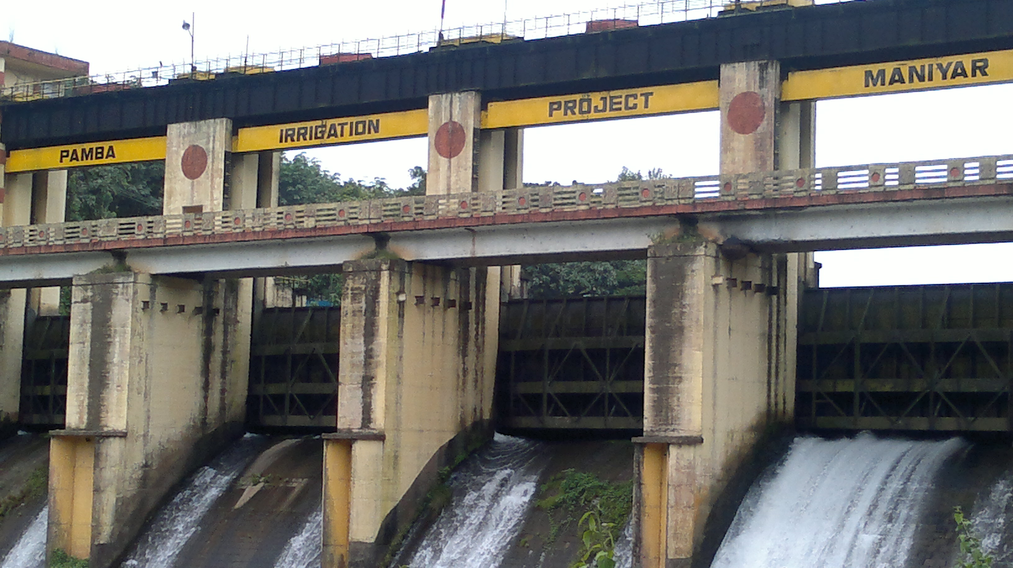


PAMBA IRRIGATION PROJECT BARRAGE AT MANIYAR
Introduction
Pamba is one of the most important rivers in the State. Rising from Sabarimala in the western ghat at an altitude around +1675 MSL. The Pamba irrigation project consists of a barrage at Maniyar across Kakkad river, a major tributary of Pamba. The river Kakkad starts from Kakkiar Malai, flow in a northwestern direction and join Pamba at Perinad. The project aims at the utilization of the firm discharge of the tailrace water of Sabarigiri Hydro Electric Project for Irrigation purposes, which let the tailrace water into the river Kakkar and is picked up at Maniyar by a barrage situated at 9o 21 N and 76o 53 E.
An ayacut of 21135 Ha of the project falls in the Pathanamthitta and Alapuzha Districts. The ayacut being generally on the right and left banks of river pampa between the rivers of Manimala and Achencoil on the right and left respectively. It covers Onattukara and the eastern fringes of the Kayal lands of Kerala known as Kuttanad. The main objective of this project is to stabilize the first and second crop in the ayacut and to raise the third crop in a portion of the ayacut. It is estimated that an additional quantity of 81600 Tonnes of paddy would be produced by this project.
This project was declared as completed during 1993 and the commissioned ayacut comes to 20718 Ha. Command Area Development Authority has brought this project under their activities for the betterment of on-farm development and allied works. The project consists of a barrage of an average height +16.76 MSL and length 115.2Km at a place 160 m upstream of personal Estate factory across the tributary Kakkad of pamba river (The barrage has completed during 1976), by which the river flow is diverted into the main canal. The main canal after traversing 20 Km along a terrain of rocky ridges and valleys through 8 numbers of tunnels for a length of 9969m and ten aqueducts, branches into two at Vazhakunnam.
The right branch crosses the Pamaba river and is called the right bank canal (RBC) and is 20.23 Km in length. The other branch called LBC continuous along the left bank of Pamba River. It has a length of 47.15Km and at 31 Km from the bifurcation point, it crosses Achencoil river at Kollakadavu. Through a network of branch canals, having a total length of 207 Km and distributaries of length 251 Km, the water is let into the ayacut. The canal details of this project are as follows.
| Details of Dam Engineers | ||
|---|---|---|
| Chief Engineer | Chief Engineer (Projects II) | |
| DAM DIVISION | Executive Engineer |
PIP Division, Chengannur |
| DAM SUB-DIVISION | Assistant Executive Engineer |
Assistant Executive Engineer, PIP Sub Division Kozhenchery |
| DAM SECTION | Assistant Engineer |
Assistant Engineer, PIP Section 4, Maniyar |
| Main canal | -20 Km | -50 Ha. (Ayacut) |
|---|---|---|
| RBC | -20.23 Km | -3747 Ha. ( “ ) |
| LBC | -47.15 Km | -17338 Ha. ( “ ) |
There are 47 branches and 183 distributors having a total length of 207 Km and 252 Km respectively. Even though at the time of construction the barrage was intended to divert water for agricultural purposes as per GO (ms) No. 24/93/IrD dated 2.7.93 we were impounded to store the water up to full reservoir level of 34.62 m to satisfy the conditions as per the above GO to facilitate enough quantities of water to M/s.Carborundum Universal Ltd.
Who has installed 3 numbers of the turbine which generate and supply 12 M.W of power to the State grid. The total storage capacity of the barrage at + 35.35 (MWL) is 8m3. The total length of the barrage comes to 115.22 mts out of which 64.31 mts is utilised as spillway comprising of 5 Nos. Vertical lift shutters of size 10.7 m X 5.5 m cresting at +29.26MSL.
| The Barrage | |
|---|---|
| Total length of barrage at top | 115.22m |
| Length of bulk heads | 50.90m |
| Length of spillway portion | 64.31m |
| Average bed level of river | 20.12m |
| Sill level of river sluice | 21.34m |
| Level of roadway | 36.88m |
| Width of roadway | 4.27m |
| Type of gates | Vertical lift type |
| Size and numbers of gates 5 Nos. | 10.7m x 5.5m |
| Head Sluice | |
|---|---|
| Sill level | 31.09m |
| Size and no. Of Sluice | 3.51 x 3.05m |
| Discharge capacity | 20.30 cumes |
| FRL at head | 34.62m |
| Canal System | |
|---|---|
| Gross comanded area | 26920 Ha |
| Cultivable comamded area | 24490 Ha |
| Irrigation area (Net) | |
| Paddy | 17,814 Ha |
| Sugarcane | 1,215 Ha |
| Sugarcane | 1,215 Ha |
| Vegetables | 1,012 Ha |
| Total | 20,040 H |
| Designed discharge at head | 20,9 cumes |
| Full supply level at head | 34.39 m |
| Full supply depth of main canal | 3.05 m |
Details of construction
- The barrage was constructed across Kakkad river in Pathanamthitta Dist., Kerala State at latitude 9o 20 N and 76o 53 E.
- The rock exposed was Charnokite
- At ch22.5 m a crushed Zone, 0.61 m wide dipping into the left abutment and treading parallel to the river.
- The rock in the sheared zone to twice its width and backfilled with concrete
- Washing and grouting were carried out initially by drilling a set of holes from the top near the heals, and another near the toe of the dam.
Type of construction
The headworks consists of a barrage 115m long across the river with a head sluice consisting of one Vent 5.51m x 3.05m. The barrage has a Central spillway portion flanked on either side of bulkhead portions.
Geometrical Dimensions
The bulkhead is s straight gravity type masonry dam flanking the spillway portion on either end. For the purpose of design, the weight of masonry is taken as 144lbs/cft and that of water as 62.5 lbs/cft. Uplift has also been considered with the value of 0.5 while checking the stability of the bulkhead. Maximum allowable compressive stress was limited to 109.366 tonnes/sqm. No tension was allowed and the resultant at any layer being kept with in the middle third. The safe sliding factor was assumed as 0.8.
Side slope
The bulkhead has a maximum top width of 5.48m and bottom width of 13.25m. The upstream face is sloping 1 H to 10V from + 19.29m to +21.64m and vertical from + 21.64m. The downstream face is sloping from 1H to 1.1V from
+18.29m to + 21.64m. 0.65H to IV from + 21.64m to + 24.69m and 0.4H to IV from 24.68m. to + 30.78m. Vertical from 30.78m to 36.88m. The bulkhead is in random rubble in cement mortar with a facing of coursed rubble masonry. The portion upstream of the drainage holes is in 1:2 ¾ cement morter to make it impervious and the remaining portion is in 1:5 C.M. The roadway at the top has a clear width of 4.27m thick and 0.76m high. The top-level is fixed at 36.83m with a free board of 1.52m over the MWL which is +35.36m. Three expansion joins are provided in the barrage and are located in the first, third and fifth spans of the spillway.
Spillway Details
The spillway was designed to pass the maximum flood discharged which has been worked out by the Ryve’s formula D=Cm 2/3 where the coefficient C is assumed to be 2000 in F B S Units. Since it is all the catchment area of the river up to the dam site was found to be 280sq.km. The maximum flood discharged has computed as 1280 cumec and hence the capacity of the spillway is fixed as 1287 cumec, as per the design furnished below:
Ln = Lt – O In hc
In = Length Corrected for end contractions
Lt = Clear length of Spillway crest
n = number of end contractions
hc = Head over crest
Lt = 5’ x 35’ = 175’
Hc = (+116.00 - + 96.00) = 20’
N = 2 x 5
In = 175 – 0.1 x 2x5x20’ = 155’
Q = Cb x Ln x (hc) 3 /2
Cb = 3.3
Q = 3.3 x 155 x 20 3 /2 = 45400 Cusec (1287 cumec)
The maximum flood level downstream of the barrage is calculated by considering vo cross sections of the river at about 936 m apart. The MFL downstream is found + 5.14m. The crest level of the body wall is fixed at +20.26m. The crest gates size 10.70 x 5.50m are of the vertical lift type.
| Spillway | |
|---|---|
| Location From ch | 20.80 m to 96.07m |
| Type | R.R in cement mortar with ashlar ogee facing and R.C.C upstream face Total Length 64.31m |
| Crest level | +29.26 |
| Design capacity of spillway | 1287 Cumecs |
| Number, type and size of gates Vertical lift types size | 10.7m x 5.5m -5nos. |
| Reservoirs features | |
| Top bank level | 36.83m |
| Maximum water level | 35.35m |
| Full Reservoir level | 34.62m |
| Minimum drawn down level | 29.26m |
| Dead storage capacity | 21.34m |
| Gross storage capacity | 8 mm |
| Freeboard over F.R.L | 2.21M |
| Freeboard over M.W.L | 1.48m |
| Area of reservoir at F.R.L | 1.08 sq.km. |
| Head sluice | |
|---|---|
| Spill level | 31.09m |
| Spill channel | |
| Spill channel | No spill channel |
| Instrumentation | |
| Instrumentation | Nil |