


Meenkara Irrigation Project
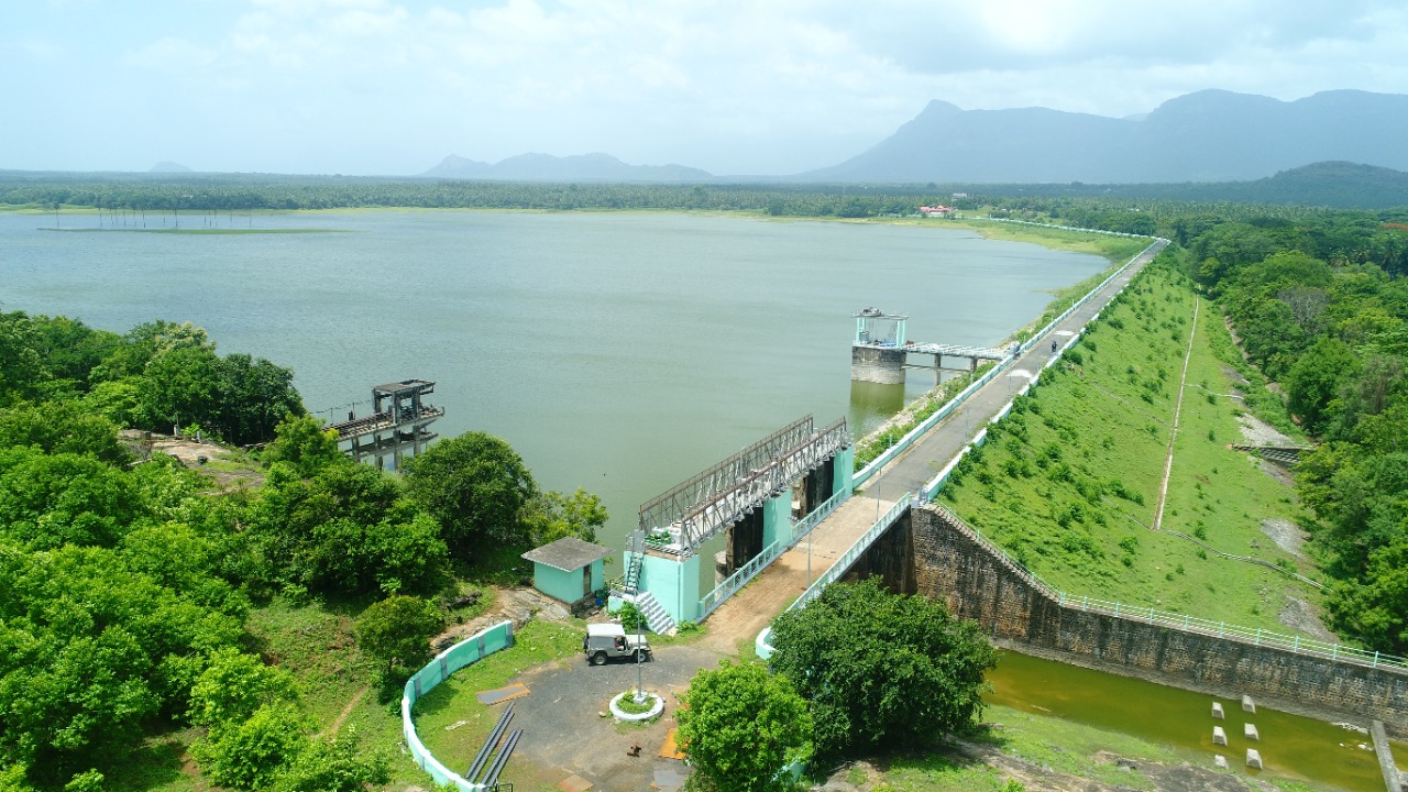
The Meenkara Irrigation Project is located in the Palakad District of Kerala State. Meenkara Dam is an earthen dam with masonry spillway section. The Meenkara dam is built across Meenkara River, a tributary of Bharathapuzha in Palakkad District and meets water requirement of an ayacut of 3035 Ha. Meenkara Project is the stage 1 of Gayathri Irrigation project. This project was taken up in 1956, partially commissioned in 1960 and completed in the year 1964. Gross storage capacity of the reservoir estimated is 11.30 Mm3 and has a catchment area of 90.65 sq. km. Out of the gross storage capacity of 11.30 Mm3, a minimum permissible storage of 1.00 Mm3 is fixed as dead storage.
Meenkara reservoir is a multipurpose reservoir in Kerala. Water stored in the Meenkara reservoir is mainly used for irrigation and a small part of storage is used for drinking water supply in nearby areas also. Water distribution for agricultural purpose generally begins in the month of November every year and continues till February or March. Major crop cultivated in the ayacut is paddy. The reservoir is located in Muthalamada Panchayath of Chittur Taluk.But it is very near to Tamilnadu boundary. The dam site is accessible by road. And it is 32 km from district headquarters and 24 km from Pollachi. The nearest towns are Kollangode in Kerala and Pollachi in Tamil Nadu. Nearest railway station is Muthalamada railway station at Kollangode and airport is at Coimbatore. The Dam is located at latitude of 10 38' N and longitude of 76 48’ E . The catchment area of Meenkara Project lies in the border region of Kerala State.
The Dam is an earth dam having total length of 964 m including 30 m length masonry in spillway portion. The height of masonry dam from foundation level is 18.9 m and 2 nos of spillway gates of size 12.19 m x 4.26 m. Size of canal sluice is 1.52 m x 1.83 m. The dam top level and spillway crest level are +158.84 m and +151.79 m respectively. The sill level of canal sluice and river sluice is +143.64 m. The FRL and MWL are +156.36 m and dead storage level corresponding to a minimum dead storage of 1.00 Mm3 is at +149.20 m
| Details of Dam Engineers | ||
|---|---|---|
| Chief Engineer | Chief Engineer (Projects I) | |
| Superintending Engineer | Siruvani Project Circle Palakkad | |
| Executive Engineer | Irrigation Division Chittoor | |
| General | |
|---|---|
| State | Kerala |
| District | Palakkad |
| Taluk/Village | Muthalamada |
| Latitude | 10° 38' North |
| Longitude | 76° 48' East |
| River | Meenkara |
| Year of Completion | 1964 |
| Structural Features of the Dam | |
| Type | Earth dam of zonal type |
| Top Width | 7.0 m |
| Bottom Width | 70.0m. |
| Length | Earthen-964m. Masonry- 30m. |
| Maximum Height | 18.9m. |
| Volume Content of Dam Body | Earth work - 0.91 Million m3 Masonry - 0.007 Million m3 Concrete - 0.00229 Million m3 |
| Slope- Upstream amp; Down stream | U/s slope 2:1,2.5:1,3:1 D/s slope 2:1,2.5:1,3:1 |
| Hydrological Features of the Dam | |
| Catchment Area | 90.65 Km2 |
| Probable Maximum Flood | 472.60 cumecs |
| Spillway | |
| Location | Right end |
| Type | Ogee type |
| Total length | 30m. |
| Crest level | 151.79 m |
| Design Capacity of Spillway | 472.60 Cumecs |
| Number, Type and Sizes of Gates | 2 nos,vertical lift type 12.19*4.57m |
| Reservoir Features | |
| Maximum water level | +156.36m. |
| Full reservoir level | +156.36m. |
| Minimum drawdown level | +143.64m. |
| Dead storage capacity | 1.0M m3 |
| Gross storage capacity | 11.33 Mm3 |
| Freeboard over F.R.L | 2.48m |
| Reservoir Area at F.R.L | 249.50 Ha |
| Free board over M.W.L | 2.44m |